
")

Vehicle Detection, Car Detection, Traffic Monitoring, Road Extraction, Driver Assistance
- Overview
- PhD theses
- Optical sensors - satellite platforms
- Optical sensors - airborne platforms
- TIR sensors - airborne platforms
- LiDAR sensors - airborne platforms
- SAR sensors - airborne platforms
- Driver assistance - mobile platforms
- Heipke C, Jacobsen K, Stilla U, Rottensteiner F, Yilmaz A, YingYang M, Skaloud J, Colomina I (2017) Preface, ISPRS Hannover Workshop: HRIGI17 – CMRT17 – ISA17 – EuroCOW17, In: ISPRS Annals of the Photogrammetry, Remote Sensing and Spatial Information Sciences, IV-1/W1: 1-2
[doi: 10.5194/isprs-annals-IV-1-W1-1-2017][Paper] - Stilla U, Rottensteiner F, Hinz S (2015) CMRT15 - City Models, Roads and Traffic 2015: Preface. ISPRS Annals of the Photogrammetry, Remote Sensing and Spatial Information Sciences, II-3/W5: 359-360
[doi:10.5194/isprsannals-II-3-W5-359-2015] - Stilla U, Rottensteiner F, Paparoditis N (2009)(eds) CMRT09 Object Extraction for 3D City Models, Road Databases, and Traffic Monitoring - Concepts, Algorithms, and Evaluation. International Archives of Photogrammetry and Remote Sensing and Spatial Information Sciences, Vol 38(3/W4)
[Content] - Mayer H, Hinz S, Stilla U (2008) Automated extraction of roads, buildings, and vegetation from multi-source data. In: Li, Chen, Baltsavias E (eds) Advances in Photogrammetry, Remote Sensing and Spatial Information Sciences: 2008 ISPRS Congress Book. London: Taylor & Francis, 213-226
[ISBN 978-0-415-47805-2] - Hinz S, Bamler R, Stilla U (2006) Editorial Theme Issue: Airborne und Spaceborne Traffic Monitoring. ISPRS Journal of Photogrammetry and Remote Sensing, 61(3-4):135-136
[doi:10.1016/j.isprsjprs.2006.09.011] - Rottensteiner F, Stilla U (2005) Report: Object Extraction for 3D City Models, Road Databases, and Traffic Monitoring - Concepts, Algorithms, and Evaluation (CMRT05).ISPRS Society, 10(3): 15-16
[Report] - Stilla U, Rottensteiner F, Hinz S (2005)(eds) Object Extraction for 3D City Models, Road Databases, and Traffic Monitoring - Concepts, Algorithms, and Evaluation (CMRT05). International Archives of Photogrammetry and Remote Sensing. Vol 36, Part 3 W24.
[Content] - Stilla U, Michaelsen E, Soergel U, Hinz S, Ender HJ (2004) Airborne monitoring of vehicle activity in urban areas. In: Altan MO (ed) International Archives of Photogrammetry and Remote Sensing. Vol 35, Part B3, 973-979
[Abstract][Paper]
- Türmer S (2014-05-06) Car detection in low frame-rate aerial imagery of dense urban areas. Dissertation. Technische Universität München (TUM), Ingenieurfakultät Bau Geo Umwelt, Photogrammetrie und Fernerkundung (Prof. Stilla).
[Dissertation] - Leitloff J (2011-09-26) Detektion von Fahrzeugen in optischen Satellitenbildern. Dissertation. Technische Universität München (TUM), Fakultät für Bauingenieur- und Vermessungswesen, Photogrammetrie und Fernerkundung (Prof. Stilla).
[Dissertation] - Yao W (2010-12-03) Extraction and velocity estimation of vehicles in urban areas from airborne laserscanning data. Dissertation. Technische Universität München (TUM), Fakultät für Bauingenieur- und Vermessungswesen, Photogrammetrie und Fernerkundung (Prof. Stilla).
[Dissertation] - Hedman K (2010-07-15) Statistical fusion of multi-aspect synthetic aperture radar data for automatic road extraction. Dissertation. Karlsruher Institut für Technologie, Fakultät für Bauingenieur-, Geo- und Umweltwissenschaften.
[Dissertation] - Wessel B (2006-05-29) Automatische Extraktion von Straßen aus SAR-Bilddaten. Dissertation. Technische Universität München (TUM), Fakultät für Bauingenieur- und Vermessungswesen, Photogrammetrie und Fernerkundung (Prof. Stilla).
[Dissertation]
Visible (VIS), optical, space-borne, satellite
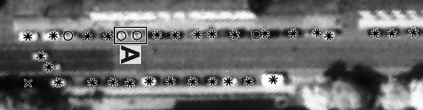 |
- Leitloff J, Hinz S, Stilla U (2010) Vehicle extraction from very high resolution satellite images of city areas. IEEE Trans. on Geoscience and Remote Sensing, 48(7): 2795-2806
[doi: 10.1109/TGRS.2010.2043109] - Leitloff J, Hinz S, Stilla U (2007) Estimation of traffic parameters in urban areas from satellite images. 2007 Urban Remote Sensing Joint event: URBAN 2007 - URS 2007, 1-6
[doi:10.1109/URS.2007.371822][Paper] - Leitloff J, Hinz S, Stilla U (2007) Inferring traffic activity from optical satellite images. In: Stilla U, Meyer H, Rottensteiner F, Heipke C, Hinz S (eds) PIA07 Photogrammetric Image Analysis 2007. International Archives of Photogrammetry, Remote Sensing, and Spatial Information Sciences, Vol 36(3/W49B): 89-93
[[Paper] - Leitloff J, Hinz S, Stilla U (2006) Automatic vehicle detection in satellite images. Symposium of ISPRS Commission III: Photogrammetric Computer Vision (PCV06). International Archives of Photogrammetry, Remote Sensing, and Spatial Information Sciences, 36(3): 221-227
[Paper] - Leitloff J, Hinz S, Stilla U (2006) Detection of vehicle queues in QuickBird imagery of city areas. PFG Photogrammetrie Fernerkundung Geoinformation, 2006(4): 315-325
- Hinz S, Leitloff J, Stilla U (2005) Context-Supported Vehicle Detection in Optical Satellite Images of Urban Areas. In: Proceedings of IEEE International Geoscience and Remote Sensing Symposium (IGARSS 2005),5: 2937-2941
[doi:10.1109/IGARSS.2005.1525684] - Leitloff J, Hinz S, Stilla U (2005) Vehicle queue detection in satellite images of urban areas. In: Moeller M, Wentz E (eds) 3th International Symposium: Remote sensing and data fusion on urban areas, URBAN 2005. International Archives of Photogrammetry and Remote Sensing. Vol 36, Part 8 W27 (on CD)
- Leitloff J, S. Hinz S, Stilla U (2005) Vehicle queue detection in complex urban areas by extraction and analysis of linear features. In: Heipke C, Jacobsen K, Gerke M (eds) High-resolution earth imaging for geospatial information. International Archives of Photogrammetry and Remote Sensing. Vol 36 Part 1 W3 (on CD)
- Leitloff J, S. Hinz S, Stilla U (2005) Automatic vehicle detection in space images supported by digital map data. In: Stilla U, Rottensteiner F, Hinz S (eds) CMRT05. International Archives of Photogrammetry and Remote Sensing. Vol 36, Part 3 W24: 75-80
[Paper]
Visible (VIS), optical, aerial, airborne, aircraft
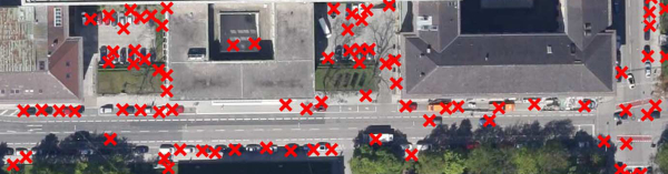 |
- Tuermer S, Kurz F, Reinartz P, Stilla U (2013) Airborne vehicle detection in dense urban areas using HoG features and disparity maps. IEEE Journal of Selected Ropics in Applied Earth Observations and Remote Sensing (JSTARS).
[doi:10.1109/JSTARS.2013.2242846] - Tuermer S, Kurz F, Reinartz P, Stilla U (2012) Airborne traffic monitoring supported by fast calculated digital surface models. In: Proceedings of IEEE International Geoscience and Remote Sensing Symposium (IGARSS 2012), 6837 - 6840
[doi:10.1109/IGARSS.2012.6352593] - Tuermer S, Leitloff J, Reinartz P, Stilla U (2011) Motion component supported boosted classifier for car detection in aerial imagery. In: Stilla U, Rottensteiner F, Mayer H, Jutzi B, Butenuth M (eds) PIA11 - Photogrammetric Image Analysis. International Archives of the Photogrammetry, Remote Sensing and spatial Information Sciences, 38 (3W/22): 215-220
[Paper] - Tuermer S, Leitloff J, Reinartz P, Stilla U (2011) Evaluation of selected features for car detection in aerial images. ISPRS Hannover Workshop 2011 (on CD)
[Paper] - Tuermer S, Leitloff J, Reinartz R, Stilla U (2011) Vehicle detection in aerial images using boosted classifier with motion mask. In: Stilla U, Gamba P, Juergens C, Maktav D (eds) JURSE 2011 - Joint Urban Remote Sensing Event, 17-20
[Paper] - Tuermer S, Leitloff J, Reinartz P, Stilla U (2010) Automatic vehicle detection in aerial image sequences of urban areas using 3D HoG features. PCV 2010 - Photogrammetric Computer Vision and Image Analysis. International Archives of Photogrammetry, Remote Sensing and Spatial Geoinformation Sciences, 38(3B): 50-54
[Paper] - Lenhart D, Hinz S, Leitloff J, Stilla U (2008) Automatic traffic monitoring based on aerial image sequences. Pattern Recognition and Image Analysis, Vol. 18 (3): 400–405
[doi: 10.1134/S1054661808030061] - Michaelsen E, Stilla U (2002) Probabilistic decisions in production nets: An example from vehicle recognition. In: Caelli T, Amin A, Duin RPW, Kamel M, Ridder Dde (eds) Structural, syntactic, and statistical pattern recognition: Joint IAPR International Workshops SSPR 2000 and SPR 2000, LNCS 2396, Berlin:Springer, 225-233
[Abstract][Abstract(Springer)] - Michaelsen E, Wankmueller U, Stilla U (2002) Comparing stereo 3-d with view-based vehicle recognition. In: Greiner G, Niemann H, Ertl T, Girod B, Seidel HP (eds) Vision, modeling, and visualization, VMV2002. Berlin:Infix, 347-354
[Abstract] - Michaelsen E, Stilla U (2000) Assessing the computational effort for structural 3D vehicle recognition. In: Ferri FJ, Inesta JM, Amin A, Pudil P (eds) Advances in Pattern Recognition: Joint IAPR International Workshops SSPR 2000 and SPR 2000, LNCS 1876. Berlin: Springer, 357-366
[Abstract][Abstract(Springer)][Paper] - Michaelsen E, Stilla U (2000) Ansichtenbasierte Erkennung von Fahrzeugen. In: Sommer G, Krüger N, Perwass C (eds) Mustererkennung 2000, Berlin:Springer, 245-252
[Kurzfassung][Paper] - Michaelsen E, Stilla U, Lütjen K (2000) Which mathematical Foundations support model based vehicle recognition. In: (eds) Pattern recognition and image analysis: Representation, processing, analysis and understanding of images. Vol. 2, 434-437
- Michaelsen E, Wankmüller U, Stilla U (1998) Wissenserwerb für Produktionsnetze zur 3D-Erkennung von Fahrzeugen. In: Levi P, Ahlers RJ, May F, Schanz M (eds), Mustererkennung 1998, Berlin: Springer, 507-514
[Kurzfassung][Paper] - Stilla U (1995) Map-aided structural analysis of aerial images. ISPRS Journal of photogrammetry and remote sensing, 50(4): 3-10
[Abstract][Paper] - Füger H, Stein G, Stilla U (1994) Multi-populations evolution strategies for structural image analysis. IEEE Conference on Evolutionary Computation (ICEC 94), Orlando, Vol I, 229-234
[doi:10.1109/ICEC.1994.350011][Abstract][Paper]
Infrared (IR), thermal (TIR), optical, airborne, aircraft
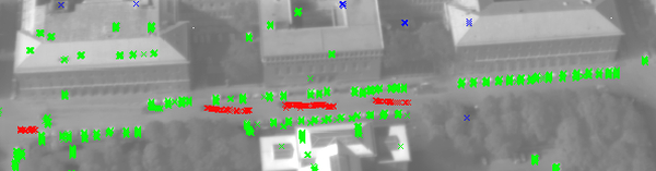 |
- Yao W, Hinz S, Stilla U (2009) Automatic estimation of vehicle activity from airborne thermal infrared video of urban areas by trajectory classification. PFG Photogrammetrie Fernerkundung Geoinformation, 2009(5): 393-406
[doi:10.1127/1432-8364/2009/0028][Paper] - Yao W, Hinz S, Stilla (2008) Automatic analysis of traffic scenario from airborne thermal infrared video. XXI Congress, Proceedings. International Archives of Photogrammetry, Remote Sensing and Spatial Geoinformation Sciences, Vol 37(B3A): 223-228
[Paper] - Hinz S, Stilla U (2006) Car detection in aerial thermal images by local and global evidence accumulation. Pattern Recognition Letters 27:308-315
[doi:10.1016/j.patrec.2005.08.013] - Kirchhof M, Stilla U (2006) Detection of moving objects in airborne thermal videos. ISPRS Journal of Photogrammetry and Remote Sensing, 61(3-4):187-196
[doi:10.1016/j.isprsjprs.2006.09.003] - Michaelsen E, Kirchhof M, Jaeger K, Stilla U (2005) Classification of local structures in airborne thermal videos for vehicle detection. In: Moeller M, Wentz E (eds) 3th International Symposium: Remote sensing and data fusion on urban areas, URBAN 2005. International Archives of Photogrammetry and Remote Sensing. Vol 36, Part 8 W27(on CD)
- Michaelsen E, Stilla U (2003) Estimation of vehicle movement in urban areas from thermal video sequences. 2nd GRSS/ISPRS Joint Workshop on Remote Sensing and data fusion on urban areas, URBAN 2003. IEEE, 105-109 (ISBN 0-7803-7719-2)
[doi:10.1109/DFUA.2003.1219967][Abstract] - Michaelsen E, Stilla U (2003) Good sample consensus estimation of 2d-homographies for vehicle movment detection from thermal videos. In: Ebner H, Heipke C, Mayer H, Pakzad K (eds) Photogrammetric Image Analysis PIA03. International Archives of Photogrammetry and Remote Sensing. Vol. 34, Part 3/W8, 125-130
[Abstract][Paper] - Stilla U, Michaelsen E (2002) Estimating vehicle activity using thermal image sequences and maps. Symposium on geospatial theory, processing and applications. International Archives of Photogrammetry and Remote Sensing. Vol. 34, Part 4
[Abstract][Paper>] - Stilla U, Michaelsen E (2002) Detektion von Fahrzeugen in Videosequenzen von luftgetragen thermischen Kameras. Östereichische Zeitschrift für Vermessung und Geoinformation VGI, 90(3+4):79-86
[Kurzfassung>][Abstract][Preprint][Paper]
LiDAR, LASER, optical, airborne, aircraft
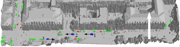 |
- Wei Y, Yao W, Wu J, Schmitt M, Stilla U (2012) AdaBoost-based feature relevance assessment in fusing airborne LiDAR and image data for classification of trees and vehicles in urban scenes. ISPRS Annals of the Photogrammetry, Remote Sensing and Spatial Information Sciences, I-7: 323-328
[Paper] - Yao W, Zhang M, Hinz S, Stilla U (2012) Airborne traffic monitoring in large areas using LiDAR data – theory and experiments. International Journal of Remote Sensing, 33(12): 3930-3945
[doi:10.1080/01431161.2011.637528] - Yao W, Wu J, Hinz S, Stilla U (2011) Investigation on the performance of velocity estimation of vehicles from airborne LiDAR data. In: Stilla U, Gamba P, Juergens C, Maktav D (eds) JURSE 2011 - Joint Urban Remote Sensing Event, 5-8
[doi: 10.1109/JURSE.2011.5764705] - Yao W, Stilla U (2011) Comparison of Two Methods for Vehicle Extraction From Airborne LiDAR Data Toward Motion Analysis. Geoscience and Remote Sensing Letters, 8(4): 607-611
[doi: 10.1109/LGRS.2010.2097239] - Yao W, Hinz S, Stilla U (2011) Extraction of motion estimation of vehicles in single-pass airborne LiDAR data towards urban traffic analysis. ISPRS Journal of Photogrammetry and Remote Sensing, 66(2011): 260-271
[doi: 10.1016/j.isprsjprs.2010.10.005] - Yao W, Hinz S, Stilla U (2010) 3D object-based classification for vehicle extraction from airborne LiDAR data by combining point shape information with spatial edge. IAPR Workshop on Pattern Recognition in Remote Sensing (PRRS), 1-4
[doi:10.1109/PRRS.2010.5742804] - Yao W, Hinz S, Stilla U (2010) Airborne Analysis and Assessment of Urban Traffic Scenes from LiDAR Data – Theory and Experiments. OTCBVS 2010
[doi:10.1109/CVPRW.2010.5543901][Paper] - Yao W, Hinz S, Stilla U (2010) Automatic vehicle extraction from airborne LiDAR data of urban areas aided by geodesic morphology. Pattern Recognition Letteres, 31(10): 1100-1108
[doi: 10.1016/j.patrec.2010.02.006] - Yao W, Hinz S, Stilla U (2009) Vehicle activity indication from airborne LiDAR data of urban areas by binary shape classification of point sets. In: Stilla U, Rottensteiner F, Paparoditis N (eds) CMRT09. International Archives of Photogrammetry, Remote Sensing and Spatial Geoinformation Sciences, Vol 38(3/W4): 187-192
[Paper] - Yao W, Hinz S, Stilla U (2009) Unveiling short-term dynamic of urban areas with airborne LiDAR data for change detection. Proceedings of the 2nd International Conference on Earth Observation for Global Changes, 1990-1998
[Paper] - Yao W, Hinz S, Stilla U (2009) Object extraction based on 3d-segmentation of LiDAR data by combining mean shift with normalized cuts: two examples from urban areas. Joint Urban Remote Sensing Event (JURSE 2009). IEEE
[doi:10.1109/URS.2009.5137673][Paper] - Yao W, Hinz S, Stilla U (2008) Traffic monitoring from airborne full-waveform LIDAR – Feasibility, simulation and analysis. XXI Congress, Proceedings. International Archives of Photogrammetry, Remote Sensing and Spatial Geoinformation Sciences, Vol 37(B3B):593-598
[Paper] - Yao W, Hinz S, Stilla U (2008) Automatic vehicle extraction from airborne LiDAR data of urban areas using morphological reconstruction. IAPR Workshop on Pattern Recognition in Remote Sensing (PRRS 2008), 1-4
[doi:10.1109/PRRS.2008.4783167]
RADAR, SAR, airborne, aircraft
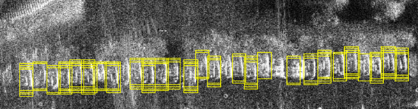 |
- Brenner AR, Essen H, Stilla U (2012) Representation of stationary vehicles in ultra-high resolution SAR and turntable ISAR images. In: 9th European Conference on Synthetic Aperture Radar (EUSAR),147-150
[Paper] - Maksymiuk O, Schmitt M, Brenner AR, Stilla U (2012) First investigations on detection of stationary vehicles in airborne decimeter resolution sAR data by supervised learning. In: Proceedings of IEEE International Geoscience and Remote Sensing Symposium (IGARSS 2012), 3584 - 3587
[doi:10.1109/IGARSS.2012.6350642] - Hedman K, Stilla U, Lisini G, Gamba P (2010) Road network nxtraction in VHR SAR images of urban and suburban areas by means of class-aided feature-level fusion. IEEE Trans. on Geoscience and Remote Sensing, 48(3): 1294-1296
[doi: 10.1109/TGRS.2009.2025123] - Stilla U, Hedman K (2010) Feature Fusion Based on Bayesian Network Theory for Automatic Road Extraction, In: Soergel U (ed) Radar Remote Sensing of Urban Areas. Dordrecht: Springer, 69-86
- Hedman K, Hinz S, Stilla U (2008) Evaluation of a Statistical Fusion of Linear Features in SAR Data. In: Proceedings of IEEE International Geoscience and Remote Sensing Symposium (IGARSS), 467-470
[doi: 10.1109/IGARSS.2008.4779759] - Hedman K, Hinz S, Stilla U (2007) Road extraction from SAR multi-aspect data supported by a statistical context-based fusion. 2007 Urban Remote Sensing Joint event: URBAN 2007 - URS 2007 (on CD)
[Paper] - Stilla U, Hinz S, Hedman K, Wessel B (2007) Road extraction from SAR imagery. In: Weng Q (ed) Remote Sensing of Impervious Surfaces. Boca Raton, FL: Taylor & Francis
[ISBN: 9781420043747] - Hedman K, Hinz S, Stilla U (2006) A Fusion Concept for Road Extraction from Multi-Aspect SAR Data. EARSEL Symposium, (on CD)
- Hedman K, Hinz S, Stilla U (2006) A Probabilistic Fusion Concept for Road Extraction from Multiple SAR Views. Proc. 6th European conference on synthetic aperture radar, EUSAR 2006. Berlin: VDE, (on CD)
- Hedman K, Hinz S, Stilla U (2006) Exploiting multi-aspect SAR data for object extraction. IEEE International Conference on Geoscience and Remote Sensing Symposium (IGARSS 2006), 2601-2604
[doi:10.1109/IGARSS.2006.672] - Hedman K, Hinz S, Stilla U (2006) A probabilistic fusion strategy applied to road extraction from multi-aspect SAR data. Symposium of ISPRS Commission III: Photogrammetric Computer Vision (PCV06). International Archives of Photogrammetry, Remote Sensing, and Spatial Information Sciences, 36(3): 55-60
[Paper] - Hedman K, Wessel B, Soergel U, Stilla U (2005) Automatic road extraction by fusion of multiple SAR views. In: Moeller M, Wentz E (eds) 3th International Symposium: Remote sensing and data fusion on urban areas, URBAN 2005. International Archives of Photogrammetry and Remote Sensing. Vol 36, Part 8 W27 (on CD)
- Hedman K, Wessel B, Stilla U (2005) A fusion strategy for extracted road networks from Multi-Aspect SAR Images. In: Stilla U, Rottensteiner F, Hinz S (eds) CMRT05. International Archives of Photogrammetry and Remote Sensing. Vol 36, Part 3 W24: 185-190
[>Paper] - Stilla U, Hedman K (2005) Road extraction from high resolution multi aspect SAR images. Proceedings of 28th General Assembly of International Union Radio Science (URSI), New Delhi, (Invited Paper), (on CD)
[Paper]
Driver assistance, visible (VIS), mobile laser scanning (MLS)
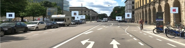 |
- Albrecht CR, Kraus S, Stilla U (2020) Detection of lane markings in road scene images taken from a top-view camera system. International Archives of the Photogrammetry, Remote Sensing and Spatial Information Sciences, XLIII-B1-2020: 205–209
[doi: 10.5194/isprs-archives-XLIII-B1-2020-205-2020] [Paper] - Borgmann B, Hebel M, Arens M, Stilla U (2020) Pedestrian detection and tracking in sparse MLS point clouds using a neural network and voting-based approach. ISPRS Annals of the Photogrammetry, Remote Sensing and Spatial Information Sciences, V-2-2020: 187–194
[doi: 10.5194/isprs-annals-V-2-2020-187-2020][Paper] - Xia Y, Liu W, Luo Z, Xu Y, Stilla U (2020) Completion of sparse and partial point clouds of vehicles using a novel end-to-end network. ISPRS Annals of the Photogrammetry, Remote Sensing and Spatial Information Sciences, V-2-2020: 933–940
[doi: 10.5194/isprs-annals-V-2-2020-933-2020][Paper][Presentation][YouTube] - Albrecht C, Kraus S, Zimmermann A, Stilla U (2019) A concept for an automated approach of public transport vehi cles to a bus stop. International Archives of the Photogrammetry, Remote Sensing and Spatial Information Sciences, XLII-2/W16: 13–20
[doi: 10.5194/isprs-archives-XLII-2-W16-13-2019][Paper] - Borgmann B, Hebel M, Arens M, and Stilla U (2019) Using neural networks to direct objects in MLS point clouds based on local point neighborhoods. ISPRS Annals of the Photogrammetry, Remote Sensing and Spatial Information Sciences, IV-2/W7: 17–24
[doi: 10.5194/isprs-annals-IV-2-W7-17-2019][Paper] - Hanel A, Stilla U (2019) Evaluation of iterative calibration of vehicle cameras using reference information from traffic signs. In: Donnellan B, Klein C, Helfert M, Gusikhin O (eds) Smart Cities, Green Technologies and Intelligent Transport Systems. SMARTGREENS 2018, VEHITS 2018. Communications in Computer and Information Science, vol 992. Cham: Springer
[doi: 10.1007/978-3-030-26633-2_12] - Hanel A, Stilla U (2019) Semantic road scene knowledge for robust self-calibration of environment-observing vehicle cameras. International Archives of the Photogrammetry, Remote Sensing and Spatial Information Sciences, XLII-2/W16: 103–110,
[doi: 10.5194/isprs-archives-XLII-2-W16-103-2019][Paper] - Hanel A, Sudi P, Pfenninger S, Steinbach E, Stilla U (2019) Filter-based pose estimation for electric vehicles relative to a ground-based charging platform using on-board camera images. 39. Wissenschaftlich-Technische Jahrestagung der DGPF, 28 54-67
[Paper] - Borgmann B, Hebel M , Arens M, Stilla U (2018) Fußgängerbezogene Informationsgewinnung zur Situationsanalyse mit einem mobilen Multisensorsystem. In: Kersten TP, Gülch E, Schiewe J, Kolbe TH, Stilla U (Hrsg) 38. Wissenschaftlich-Technische Jahrestagung der DGPF, 27: 363-375
[Paper] - Borgmann B, Hebel M, Arens M, Stilla U (2018) Usage of multiple LiDAR sensors on a mobile system for the detection of persons with implicit shape models. International Archives of the Photogrammetry, Remote Sensing and Spatial Information Sciences, XLII-2: 125–131
[doi: 10.5194/isprs-archives-XLII-2-125-2018][Paper] - Hanel A, Kreuzpaintner D, Stilla U (2018) Evaluation of a traffic sign detector by synthetic image data for advanced driver assistance systems. International Archives of the Photogrammetry, Remote Sensing and Spatial Information Sciences, XLII-2: 425–432
[doi: 10.5194/isprs-archives-XLII-2-425-2018][Paper] - Hanel A, Mitschke A, Boerner R, VanOpdenbosch D, Hoegner L, Brodie D, Stilla U (2018) Metric scale calulations for visual mapping algorithms. International Archives of the Photogrammetry, Remote Sensing and Spatial Information Sciences, XLII-2: 433–440
[doi: 10.5194/isprs-archives-XLII-2-433-2018][Paper] - Hanel A, Stilla U (2018) Traffic sign detection and recognition with convolutional neural networks. In: Kersten TP, Gülch E, Schiewe J, Kolbe TH, Stilla U (Hrsg) 38. Wissenschaftlich-Technische Jahrestagung der DGPF, 27: 355-362
[Paper] - Hanel A, Stilla U (2018). Iterative calibration of a vehicle camera using traffic signs detected by a convolutional neural network. Proceedings of the 4th International Conference on Vehicle Technology and Intelligent Transport Systems (VEHITS), 1: 187-195
[doi: 10.5220/0006711201870195] - Borgmann B, Hebel M, Arens M , Stilla U (2017) Konzept zur Gefährdungserkennung im städtischen Verkehrsraum durch Personendetektion in MLS-Punktwolken. In: Kersten TP (Hrsg) 37. Wissenschaftlich-Technische Jahrestagung der DGPF, 26: 262-275
[Paper] - Borgmann B, Hebel M, Arens M, Stilla U (2017) Detection of persoms in MLS point clouds. The International Archives of the Photogrammetry, Remote Sensing and Spatial Information Sciences, XLII-2/W7: 203-210
[doi: 10.5194/isprs-archives-XLII-2-W7-203-2017][Paper] - Hanel A, Stilla U (2017) Calibration of a vehicle camera system with divergent fields-of-view in an urban environment. In: Kersten TP (Hrsg) 37. Wissenschaftlich-Technische Jahrestagung der DGPF, 26:160-169
[Paper] - Hanel A, Stilla U (2017) Structure-from-motion for calibration of a vehicle camera system with non-overlapping fields-of-view in an urban environment. In: The International Archives of the Photogrammetry, Remote Sensing and Spatial Information Sciences, XLII-1-W1: 181-188
[doi: 10.5194/isprs-archives-XLII-1-W1-181-2017][Paper] - Hanel A, Kloeden H, Hoegner L, Stilla U (2016) Personendetektion in Grauwertbildern eines Stereo-Fahrzeugkamerasystems in Nachtsituationen mit variierenden Beleuchtungsverhältnissen. In: Kersten TP (Hrsg) 36. Wissenschaftlich-Technische Jahrestagung der DGPF, 177-187
[Paper] - Hanel A, Hoegner L, Stilla U (2016) Towards the influence of a car windshield on depth calculation with a stereo camera system. International Archives of the Photogrammetry, Remote Sensing and Spatial Information Sciences, XLI-B5: 461-468
[doi:10.5194/isprs-archives-XLI-B3-241-2016][Paper] - Hanel A, Kloeden H, Hoegner L, Stilla U (2015) Image based recognition of dynamic traffic situations by evaluating the exterior surrounding and interior space of vehicles. The International Archives of the Photogrammetry, Remote Sensing and Spatial Information Sciences, XL-3/W3: 161-168
[doi:10.5194/isprsarchives-XL-3-W3-161-2015][Paper] - Hanel A, Kloeden H, Hoegner L, Stilla U (2015) Erkennung von Szenebeleuchtungen aus Bildern eines Fahrzeugkamerasystems zur Verbesserung der Objektdetektion. In: Kersten TP (Hrsg) 35. Wissenschaftlich-Technische Jahrestagung der DGPF, 254-262
[Paper] - Michaelsen E, Stilla U (2000) Assessing the computational effort for structural 3D vehicle recognition. In: Ferri FJ, Inesta JM, Amin A, Pudil P (eds) Advances in Pattern Recognition: Joint IAPR International Workshops SSPR 2000 and SPR 2000, LNCS 1876. Berlin: Springer, 357-366
[Abstract][Abstract(Springer)][Paper] - Michaelsen E, Stilla U (2000) Ansichtenbasierte Erkennung von Fahrzeugen. In: Sommer G, Krüger N, Perwass C (eds) Mustererkennung 2000, Berlin:Springer, 245-252
[Kurzfassung][Paper] - Michaelsen E, Stilla U, Lütjen K (2000) Which mathematical Foundations support model based vehicle recognition. In: (eds) Pattern recognition and image analysis: Representation, processing, analysis and understanding of images. Vol. 2, 434-437
- Sörgel U, Schulz K, Thönnessen U, Stilla U (2000) 3D-Visualization of interferometric SAR data. EUSAR00, 305-308
[Abstract][Paper] - Michaelsen E, Wankmüller U, Stilla U (1998) Wissenserwerb für Produktionsnetze zur 3D-Erkennung von Fahrzeugen. In: Levi P, Ahlers RJ, May F, Schanz M (eds), Mustererkennung 1998, Berlin: Springer, 507-514
[Kurzfassung][Paper]